Africa

mp422MP 422


Colonie dell’Africa orientale Italiana E Abissinia. Size: 50 x 70cm. m

Price: $390.00

mp410MP 410mp410aMP 410


African History in Maps, by Michael Kwamena-Poh, John Tosh, Richard Waller and Michael Tidy. B EH

Price: $120.00

mp343MP 343mp343aMP 343mp343bMP 343


Colonie D’Italia, Africa Orientale. Cover included. The map shows advertisement from Omaggio della Casa “Olla” Roma. Size: 30x38cm. M

Price: $200.00

mp338MP 338mp338aMP 338


Carta Geografica dell’Africa Orientale Italiana. A gift of the Assicurazioni Generali di Trieste e Venezia. Size: 44x55cm. Scale 1:5000000. Shows the locations of offices of the donor throughout the newly formed 5 administrative states of the newly formed Africa Orientale Italiana. m

Price: $300.00

mp332MP 332mp332aMP 332


Tunisa, by the Consociazione Turistica Italiana. 1941. Scale 1:500000. Size:96x137cm. Cover included. B

Price: $300.00

mp222MP 222mp222aMP 222

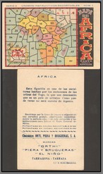
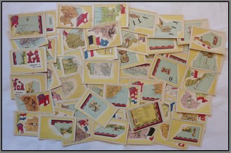
Unusual and rare complete set of Spanish Cromos Instructivos Recortables, Mapa de Africa. Done in the 1920’s, each card contains an African motif as well as a piece of the puzzle to be cut out. The 60 cut out pieces form the complete map of Africa. Each back contains advertising as well as some notes about the region on the front of the card. It has taken me 15 years to complete this set. M

Price: $1100.00

mp198MP 198


Italian propaganda map of the Italo-Turco war in Libya in 1912. Size 44x64cm. m

Price: $690.00

mp170MP 170 mp170aMP 170 mp170bMP 170

Group of 5 cloth backed maps from the same series. Carta della Somalia Publicazione Diretta dal Servizio Cartografico del Ministero delle Colonie. Diretrtore del Servizio: A. Dardano. 1930. Size: 58 x 59 Each. Scale unknown. Includes : Foglio 17 Itala (with insert map), Foglio 13 Obbia (with insert map), Foglio 7 Rocca Littorio, Foglio 4 Callis, Foglio 17. Mogadiscio. M

Price: $1000.00

mp135MP 135


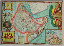
Spectacular illustrated Mapa de Abisinia (Etiopia) by Chocolate San Fernando of Barcelona. Very rare. Size: 46x64cm. m AH EN

Price: $1000.00

mp150MP 150mp150aMP 150


Atlas Missionario Portugues. Missao para o Estudo da Missionologia Africana. Centro de Estudos Politicos e Sociais Junta de Investigacoes do Ultramar. Lisbon 1962. A nice thick atlas giving maps and details of Portuguese catholic and protestant missions throughout the Portuguese colonies. Size 24x33cm. B

Price: $400.00

mp150bMP 150 mp150cMP 150 mp150dMP 150 mp150eMP 150 mp150fMP 150

mp149MP 149


Atlas de Mocambique. Editado Pela Empresa Moderna, LDA. Lourenco Marques – 1962. A 43 page atlas covering all aspects of Mozambique. Size 29x38cm. B

Price: $400.00

mp149aMP 149 mp149bMP 149 mp149cMP 149
mp114MP 114 Porto de Marmugao E Barra do Zuari. 

Ministerio Das Colonias 1933

Scale: 1:15000

Size: 81 x 96 M

Price: $90.00

mp113MP 113


Carta de Angola. Ministerio Do Ultramar 1960. Scale: 1:1000000. Size: 67 x 80cm. B EH

Price: $110.00

mp111MP 111


Carta de Angola. Ministerio Do Ultramar 1960. Scale: 1:1000000. Size: 66 x 80cm. M

Price: $110.00

mp082MP 082


Africa Oriental Portugueza Mocambique, Zavalla. Folha No. 14. Repaired. Commissao de Cartographia (Portugal) 1897. Size: 47 x 49cm. Scale: 1: 1000000. M

Price: $70.00

mp081MP 081


Africa Oriental Portugueza Mocambique, Gaza. Folha No. 10. Repaired. Commissao de Cartographia (Portugal) 1897. Size: 47 x 49cm. Scale: 1: 1000000. M

Price: $80.00

Copyright © 2013-2024 History Revealed